


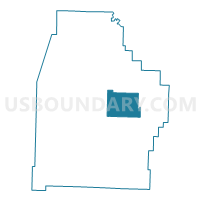
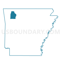
Whorton Voting District, Madison County, Arkansas
About
Outline

Summary
| Unique Area Identifier | 527232 |
| Name | Whorton Voting District |
| County | Madison County |
| State | Arkansas |
| Area (square miles) | 33.71 |
| Land Area (square miles) | 33.56 |
| Water Area (square miles) | 0.15 |
| % of Land Area | 99.56 |
| % of Water Area | 0.44 |
| Latitude of the Internal Point | 36.00846260 |
| Longtitude of the Internal Point | -93.61943060 |
Maps

Graphs
Select a template below for downloading or customizing gragh for Whorton Voting District, Madison County, Arkansas


Neighbors
Neighoring Voting District (by Name) Neighboring Voting District on the Map
- Bowen Voting District, Madison County, AR
- Kings River Voting District, Madison County, AR
- Purdy Voting District, Madison County, AR
- Venus Voting District, Madison County, AR
- War Eagle 2 Voting District, Madison County, AR
Top 10 Neighboring County Subdivision (by Population) Neighboring County Subdivision on the Map
- War Eagle township, Madison County, AR (4,037)
- Kings River township, Madison County, AR (769)
- Bowen township, Madison County, AR (486)
- Wharton township, Madison County, AR (418)
- Purdy township, Madison County, AR (314)
- Venus township, Madison County, AR (244)